Flinders Range
Flinders Range, Flinders Ranges SA 5434, AustraliaFlinders Range Overview
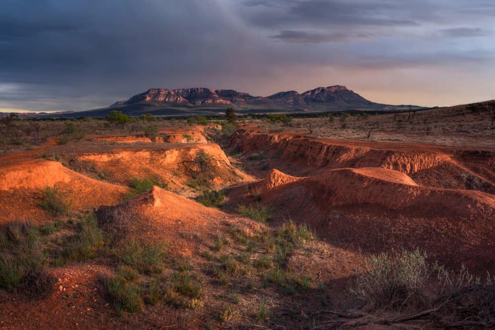
Flinders Range is a sprawling mountain range in South Australia that stretches for roughly 430 kilometers from the Peterborough area in the north down to the Barossa Valley region in the south. The range rises abruptly from surrounding plains and flatlands, creating a dramatic landscape of ridges, valleys, and red earth that has captivated visitors for over a century. The most visited section sits around Wilpena Pound, a natural amphitheater of mountains that forms the heart of Flinders Ranges National Park.
This is not a single peak or a compact hiking destination. Flinders Range is a vast geological formation that defines much of South Australia's interior character. The landscape shifts from lush creek beds and native forests in the south to drier, more austere terrain toward the north, where the Flinders eventually flatten into the Gammon Ranges.
Why This Place Matters
Flinders Range holds deep significance for the Adnyamathanha people, the traditional owners of this land for thousands of years. The mountains are woven into their cultural stories and spiritual practices. European explorers documented the range in the 1800s, and it became a centerpiece of South Australian tourism during the early twentieth century.
Geologically, the range is ancient. Its rocks date back over 800 million years, telling a story of uplift, erosion, and dramatic landscape evolution. For visitors, it offers something rare in South Australia: genuine wilderness within reach, plus accessibility to Aboriginal cultural heritage.
Quick Facts
- Stretches approximately 430 kilometers north to south across South Australia
- Wilpena Pound, the iconic natural basin, sits at the heart of Flinders Ranges National Park
- The highest point, Saint Mary Peak, reaches 1,171 meters above sea level
- The range is roughly 80 kilometers northeast of Adelaide by road
- Best visited during autumn and spring when temperatures are moderate
- The main visitor hub is the small town of Hawker, about 30 kilometers from Wilpena
Getting There
Most visitors approach Flinders Range from Adelaide. The drive to Wilpena Pound takes roughly three and a half hours via the Princes Highway and Flinders Ranges Road. Alternatively, you can take the scenic inland route through the Barossa Valley, which adds time but passes wine regions and small historic towns.
If you're without a car, regional bus services operate between Adelaide and towns like Hawker and Brachina, though frequency is limited and journey times are considerably longer. Having your own transport makes exploring the range far more flexible, as distances between attractions are substantial and public transport within the ranges themselves is minimal.
The closest commercial airport is Adelaide Airport, about 40 kilometers south of the city center. From there, rental car options are available, though advance booking is advisable during peak seasons.
The Layout and Experience
Flinders Range is best understood as a series of distinct regions rather than a single site. The southern sections near Barossa and Tanunda offer gentler terrain and easier access. The central region around Wilpena Pound concentrates the most dramatic scenery and the largest number of walking trails. The northern sections, including the Gammon Ranges, are more remote and require greater preparation.
Wilpena Pound itself is a natural basin surrounded by mountains, roughly 9 kilometers long and 5 kilometers wide at its widest point. The floor of the pound is relatively flat, dotted with red earth, scattered vegetation, and creek beds that flow after rain. The surrounding walls rise steeply, creating walls of weathered rock and creating the sense of being inside a natural fortress.
The visitor experience varies sharply depending on effort level. You can drive to Wilpena, stay at the lodge or nearby accommodation, and take short walks of an hour or two. Or you can spend days hiking longer trails that climb ridges, traverse creek valleys, and demand proper fitness and preparation. Many visitors split the difference: a day drive with two or three walks of moderate length.
Main Highlights
Saint Mary Peak is the signature climb. The walk from Wilpena Pound takes roughly four to five hours round trip, ascending steeply through native vegetation and rocky terrain to views that, on clear days, extend across the entire range and beyond to the surrounding plains. The final approach scrambles over loose rock and requires care, but the summit itself is not technical.
Wilpena Pound Walk is a gentler alternative that loops around the base of the surrounding ridges without climbing to high points. The walk takes roughly two and a half to three hours and passes through red earth country with scattered native trees and rocky outcrops. Early morning or late afternoon light transforms the colors here, making these times ideal for photography.
Brachina Gorge, in the southern ranges, offers a completely different experience. The narrow gorge cuts through layered rock formations that tell a geological story spanning over 800 million years. A gentle walk through the gorge takes around an hour and is suitable for visitors with limited mobility or time constraints.
Rawnsley Bluff provides another popular walk with excellent views over Wilpena and the surrounding country. The hike is shorter and less demanding than Saint Mary Peak, typically taking two to two and a half hours, and the vantage point is exceptional for sunrise or sunset photography.
Warren Gorge, also in the southern section, features a small waterfall and cool creek bed that feels removed from the drier ridges above. The walk is relatively short and often feels less crowded than the more famous trails.
History and Background
The Adnyamathanha people have inhabited these mountains for at least 20,000 years, and likely far longer. The landscape contains sacred sites, cultural markers, and stories embedded in the geography itself. Mountain names, water sources, and trails all carry cultural significance that shaped how people moved through and understood the land.
European exploration began in earnest during the 1820s and 1830s. Captain Mark Latham led one of the first expeditions through the range in 1839. Subsequent surveyors and explorers documented the terrain, and by the late 1800s, the range had become a destination for intrepid travelers seeking dramatic scenery.
Flinders Ranges National Park was established in 1945, protecting the central and most visually striking sections. The park has been expanded and refined several times since. Early tourism infrastructure, including the Wilpena Pound lodge and basic walking trails, was developed during the mid twentieth century.
Tickets and Entry
Flinders Ranges National Park requires an entry fee. You can purchase a day pass or a longer multi-day pass at the gate when you arrive, or online in advance. Rates vary by vehicle type and duration. The gate at Wilpena Pound is staffed during daylight hours, and payment is also available through an honor system outside staffed hours.
Some sections of the broader Flinders Range, particularly in the north and on private pastoral land, have no formal entry fee but may require permission from landholders. The national park itself covers the most visited areas and is the main place where you'll encounter formal entry requirements.
Best Time to Visit
Autumn, from March through May, and spring, from September through November, offer ideal conditions. Temperatures are moderate, rarely extreme, and daylight hours are sufficient for full-day hikes. Wildflowers bloom in spring, painting the landscape with color after winter rains.
Summer, from December through February, brings heat that can reach the low forties Celsius in some areas. Walking becomes strenuous, water sources are critical, and the landscape appears drier. Many locals and experienced hikers avoid summer entirely or undertake only very early morning or late evening walks.
Winter, from June through August, brings cooler temperatures and occasional rain. Days are shorter, which limits hiking time. However, the light is often clearer, and the landscape after rain has a particular beauty. Winter is less crowded than spring and autumn.
Avoid school holiday periods if you prefer solitude. The ranges attract many family visitors during these times, and popular walking trails and accommodation fill quickly.
Photography Tips
The red earth and weathered rock of Flinders Range photograph best in soft light. Early morning and late afternoon bring warm tones to the landscape and create pronounced shadows that add depth and dimension. Midday light flattens colors and reduces contrast.
Sunrise from Saint Mary Peak or Rawnsley Bluff is spectacular, but requires either camping nearby or arriving very early. Sunset from the same vantage points offers similar rewards and is often easier to time since you're descending in darkness rather than ascending before light.
The narrow gorges, particularly Brachina and Warren, create dramatic compositions with layered rock walls and shadows. Shoot during the hours when the sun is angled into the gorge rather than directly overhead.
Wide-angle lenses work well for capturing the scale of the landscape and the sweep of valleys. Longer lenses compress distant ridges and can emphasize the texture of rock formations. The red earth is vibrant enough that color saturation in photographs often needs mild reduction to appear natural.
Facilities and Preparation
Wilpena Pound has the most developed facilities, including a visitor center, a lodge with accommodation, a general store, and a restaurant. Facilities are basic but functional. The visitor center provides maps, walking information, and advice from staff.
Hawker, the nearest town outside the park, offers petrol stations, grocery shops, cafes, and accommodation ranging from budget to mid-range options. It's a practical base if you prefer staying outside the park or want more dining variety.
Water is essential. Carry at least two liters per person for any walk longer than an hour. While some trails pass creeks, water reliability depends on recent rainfall, and untreated water carries risk. Bring your own supply or use purification tablets.
Mobile phone coverage is patchy and unreliable across much of the range. Do not rely on your phone for navigation or emergency contact in remote areas. Carry paper maps and inform someone of your intended route and expected return time before setting out on longer walks.
Sturdy walking shoes with good ankle support and grip are essential. The terrain is rocky, uneven, and often steep. Loose rock can shift underfoot. Many trails are not formally maintained, so footing is unpredictable in places.
Sun protection is critical. The sun exposure is intense, and shade is limited on exposed ridges and in open country. Bring sunscreen, a wide-brimmed hat, and sunglasses. The landscape offers little protection from wind, which can be surprisingly strong on high points.
How It Compares to Similar Places
Flinders Range differs from other Australian mountain ranges in its accessibility and scale. It's far easier to reach than remote ranges in Tasmania or the Australian Alps, yet offers genuine wilderness and solitude compared to more developed tourist regions.
The geological story here is more legible than in many places. The Brachina Gorge geological walk, in particular, makes the ancient rock layers readable to non-specialists in a way that rewards curiosity without requiring technical knowledge.
Compared to the Blue Mountains west of Sydney or the Dandenong Ranges near Melbourne, Flinders Range is drier, hotter, and less densely forested. The aesthetic is starkly different: red earth and sparse vegetation rather than eucalypt forests and ferns.
Combining With Nearby Attractions
The Barossa Valley lies roughly 40 kilometers south of the southern Flinders Range. If you're visiting the range, many travelers combine the trip with wine tastings and cellar door visits in the valley. The drive takes roughly an hour from Wilpena.
The small towns of Quorn and Peterborough are historic railway towns with heritage attractions and local character. Quorn is roughly an hour south of Wilpena and makes a practical stop for fuel or a meal.
Parachilna Gorge and the Parachilna Gorge Hotel are in the northern ranges, about 90 minutes from Wilpena. The hotel serves locally sourced meals using native ingredients and offers a unique dining experience in remote country.
Clare Valley, another wine region, lies to the southeast, roughly 70 kilometers away by road.
Sample Visit Plan
A two-day visit centered on Wilpena Pound is practical for most visitors. Arrive on day one in the afternoon, settle into accommodation, and take a short walk like Warren Gorge or a portion of the Wilpena Pound Walk to acclimatize. Enjoy dinner and rest.
Day two, start early and climb Saint Mary Peak, returning by mid-afternoon. This gives you the main highlight and leaves flexibility for a shorter second walk or simply rest and photography time.
A three-day visit allows you to add a second area. Day one remains the same. Day two, climb Saint Mary Peak. Day three, drive south to Brachina Gorge for the geological walk and explore the southern ranges before returning south toward Barossa or Adelaide.
For a longer four or five-day visit, you can include multiple regions, attempt longer trails like the Flinders Ranges Walk (a multi-day trek), and spend time exploring creeks and smaller valleys that reward slower travel.
Practical Tips
- Start walks early in the day to maximize daylight and avoid hiking in darkness if you underestimate time
- Check weather forecasts before setting out; conditions can change rapidly and storms are possible in spring and early summer
- Download offline maps before you arrive, as mobile coverage is unreliable
- Bring more water than you think you'll need; dehydration is a common issue in the dry climate
- Wear layers; mountain temperature can drop significantly, especially on exposed ridges and after sunset
- If hiking alone, leave detailed information about your route and expected return time with your accommodation or a contact person
- Allow extra time for walks if you're not accustomed to steep terrain or high altitude; the pace is slower than flat ground
- The lodge at Wilpena books quickly during peak seasons; reserve well in advance if this is your preference
- Fill your fuel tank in Hawker or larger towns; petrol stations are sparse and distances are long
FAQ
Can I visit Flinders Range as a day trip from Adelaide? Yes, though it's a full day of driving. You'll have roughly three to four hours to spend in the range itself. Most visitors prefer at least one overnight stay to enjoy multiple walks and arrive relaxed.
Is Saint Mary Peak suitable for beginners? It's achievable for people in reasonable fitness, but it's steep and rocky. The ascent is relentless without technical climbing. If you're uncertain about your fitness, try a shorter walk first to gauge your comfort level.
What should I do if I get lost on a trail? Stay calm and retrace your steps if possible. Do not continue in an uncertain direction. If you have mobile coverage, call for help. If not, stay visible and make yourself heard. Inform someone of your expected return time before you depart so search efforts begin promptly.
Are there guided walks available? Yes, the visitor center at Wilpena can provide information about guided tours and walks. Local tour operators offer guided hikes and sometimes Aboriginal cultural tours, though availability varies by season.
Can I camp in the national park? Camping is available at designated areas within Flinders Ranges National Park. The main campground is at Wilpena Pound. Booking in advance is essential during peak seasons. Some backcountry camping is permitted in certain areas with a permit.
Reviews
Sign in and mark this place visited to leave a review.
No reviews yet.
Free Trip Planner
Plan your Flinders Ranges trip with our free planner
Build a day-by-day itinerary with AI suggestions, hand-picked places, and friends. Free forever — no credit card.