Binevenagh
Binevenagh, Limavady BT49 0JF, UKBinevenagh is the basalt escarpment that rises above the eastern shore of Lough Foyle, a short drive from Limavady in County Londonderry. Seen from the Roe Valley below, it reads as a dark wall of volcanic rock, dropping close to 400 metres to the flat farmland and the lough beyond. Drive to the top, though, and the character flips entirely. The summit is a wide, flat, grassy plateau, open to whatever weather is coming off the Atlantic, with almost nothing to break the horizon. Most people now recognise it as the Dothraki Sea from Game of Thrones, the grassland where Daenerys Targaryen lands on Drogon and is slowly encircled by the khalasar. Binevenagh was a working hillside and a local walking spot long before the production arrived, and it still functions as one for people in Limavady and Castlerock regardless of what happens on screen.
Why Binevenagh matters
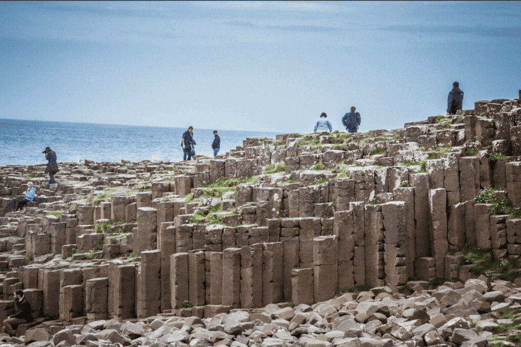
Binevenagh sits at a point where geology, scenery and screen tourism overlap more directly than at most filming locations. The cliffs belong to the same basalt lava flows that formed the Giant's Causeway and the wider Antrim Plateau, laid down around 60 million years ago when this corner of Ireland was volcanically active. Millions of years of erosion since then have cut the escarpment back into the sheer face you see today, with Lough Foyle and the Donegal hills spread out below it.
That pairing of a dramatic edge and a flat, open top is unusual, and it's exactly what made the site useful to a camera crew. The plateau reads as unbroken grassland with no pylons, roads or buildings in frame, which is harder to find in Northern Ireland than you might assume given how small the country is. For visitors the result is practical: you get the geology and the pop-culture reference in the same short detour, without having to choose one over the other.
Quick facts
- Location: Binevenagh, Limavady, County Londonderry, Northern Ireland, BT49 0JF
- Type: basalt escarpment and upland plateau, part of the Binevenagh Area of Outstanding Natural Beauty
- Elevation: the plateau reaches close to 385 metres above sea level at its highest points
- Game of Thrones connection: used as the Dothraki grasslands where Daenerys lands on Drogon
- Access: a public road leads up to a car park near the summit, with no ticket or entry fee
- Nearest town: Limavady, roughly 15 minutes away by car
Getting there
Binevenagh is reached by minor roads off the A2 coast road between Limavady and Castlerock, or from the B201 if you're coming up from the Roe Valley. The climb starts gently among hedged farm lanes, then opens out fast, so that within a few minutes you go from enclosed countryside to bare hillside with long views back over the valley.
There's a small car park near the top, close to Binevenagh Lake, and from there the viewpoint and the plateau edge are only a short walk. You don't need a 4x4 or any special preparation to get up there in normal conditions, which is a big part of why it works as an easy add-on to a day spent along the Causeway Coast. The road does narrow in places, though, and there's little in the way of barriers near the summit, so it's worth taking the last stretch slowly, especially if you're not used to single-track roads with passing places.
The layout and experience
The site has two distinct characters, and it's worth seeing both rather than just ticking off the viewpoint. Below the car park, Binevenagh Lake sits in a sheltered dip, a small reservoir ringed by forestry and reed beds. It's a quieter, more enclosed spot, popular with dog walkers and good for a short loop if you want to stretch your legs without committing to the exposed summit.
Above it, a path leads out onto the open plateau and the cliff edge proper, where the ground flattens into exactly the kind of unbroken grassland that made it work on screen. Stand at the edge and the land drops away almost immediately below you. Lough Foyle spreads out beneath the cliff, with the Inishowen peninsula and the Donegal hills across the water, and on a genuinely clear day the view carries far enough to pick out the Scottish islands on the horizon. It's a lot of geography packed into one sightline for a place you can drive most of the way to.
History and background
The rock itself tells the oldest part of the story. Binevenagh's basalt formed during the same volcanic episode that produced the hexagonal columns at the Giant's Causeway, roughly an hour's drive north, part of a vast outpouring of lava across what is now County Antrim and County Londonderry around 60 million years ago. Over millions of years, weathering and the retreat of ice age glaciers cut the escarpment back into the cliff line visible now, leaving the plateau on top relatively undisturbed by comparison.
More recently, Binevenagh has functioned as common land and rough grazing, with the lake built as a reservoir rather than occurring naturally. The whole area is designated an Area of Outstanding Natural Beauty, recognising both the escarpment and the views over Lough Foyle, and it has long been known locally as a spot for walkers wanting a wide view without a long hike.
Then came Game of Thrones. The production used the plateau's flat, treeless expanse to stand in for the Dothraki Sea, the grassland setting for the scene in which Daenerys Targaryen, having emerged unburned from Drogon's fire, is found kneeling and is slowly surrounded by the khalasar rising around her from the grass. It's one of the more visually striking moments in the series, and the location does a lot of the work. An open horizon with nothing modern in frame is exactly what Binevenagh's summit supplies naturally, without any set dressing. For fans tracing Westeros locations across Northern Ireland, it sits alongside the Dark Hedges and the Causeway Coast quarries as one of the more recognisable backdrops, and one of the easier ones to reach by car.
Best time to visit
Binevenagh is exposed on all sides, so weather does more to shape a visit here than at almost any other stop on the Causeway Coast. Clear, calm days give you the full view across Lough Foyle to Donegal and, occasionally, as far as the Scottish islands. Low cloud or mist, which rolls in off the Atlantic without much warning, can cut visibility to a few hundred metres and turn the plateau into something closer to featureless moorland. Mornings tend to be calmer and clearer than afternoons, particularly in spring and autumn, and the lower, golden light suits photographs of the escarpment edge. Wind is a near-constant at the summit, so even a mild day in the valley can feel considerably sharper up top.
Combining with nearby attractions
Binevenagh works well as a short detour rather than a destination in its own right, which suits how most people encounter it. The Giant's Causeway and the rope bridge at Carrick-a-Rede are both within easy driving distance along the coast, and Binevenagh's basalt gives useful context for the Causeway's columns if you visit both on the same day. Castlerock and its beach sit just below the escarpment to the north, and Limavady itself, with the Roe Valley Country Park, is about 15 minutes away by car. If you're already tracing Game of Thrones filming sites along this stretch of coast, Binevenagh pairs naturally with the Dark Hedges near Armoy and the quarry locations closer to the coast road.
Practical tips
- Bring a windproof layer even in summer, since the exposed plateau is consistently colder and windier than the valley below
- Check the forecast for low cloud or mist before you set out, as it can remove the view entirely with little warning
- The access road has no barriers near the summit, so drive the final stretch slowly and watch for walkers and sheep
- There's no ticket booth or formal facilities on site, so treat it as an open landscape rather than a managed attraction
- Sturdy footwear helps, since the ground near the cliff edge can be wet and uneven even in dry weather
FAQ
Is there an entry fee for Binevenagh?
No. It's open access land with a public road and car park, and there's no ticket or admission charge.
Can you drive all the way to the Game of Thrones viewpoint?
Almost. A public road takes you to a car park near Binevenagh Lake, close to the summit, and the plateau edge used in the Dothraki Sea scene is a short walk from there.
How far is Binevenagh from the Giant's Causeway?
Roughly an hour's drive, and the two sites share the same volcanic basalt origin, which makes them a natural pair to visit on the same day.
Is Binevenagh suitable for a quick stop, or does it need a full visit?
Most visitors spend somewhere between 30 minutes and an hour, enough time to walk from the car park to the cliff edge and back, which makes it an easy add-on rather than a half-day commitment.
Reviews
Sign in and mark this place visited to leave a review.
No reviews yet.
Free Trip Planner
Plan your Limavady trip with our free planner
Build a day-by-day itinerary with AI suggestions, hand-picked places, and friends. Free forever — no credit card.