Overview
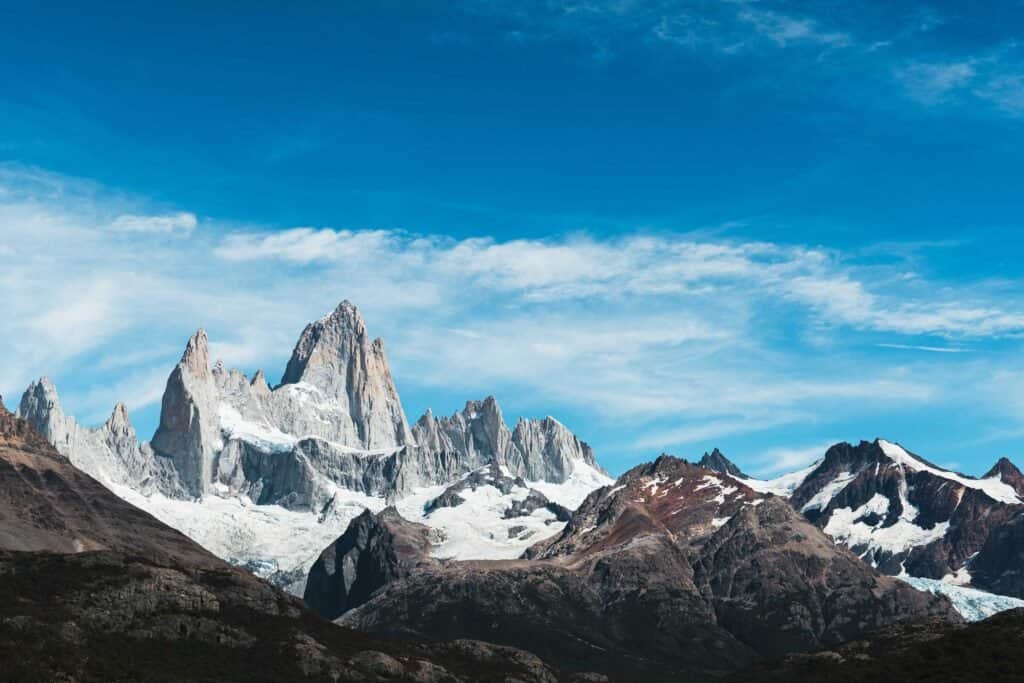
El Chaltén sits at the northern edge of Los Glaciares National Park in Argentina's Santa Cruz Province, roughly 220 kilometers from El Calafate. This small mountain town of about 3,000 residents has become the trekking capital of Patagonia, drawing hikers from across the world to tackle its dramatic peaks and pristine wilderness. The two mountains that define the town are Fitz Roy and Cerro Torre, both iconic summits that rise sharply from the steppe and dominate the skyline from almost every angle.
The town itself feels more like a hiking base camp than a traditional tourist destination. There are no traffic lights, no chain restaurants, and no pretense. What you get instead is a tight-knit community of guides, hostel owners, and travelers united by a love of mountains and the outdoors. Most people come for one reason: to walk into the wilderness and test themselves against the landscape.
Why this place matters
El Chaltén represents something increasingly rare in modern tourism: a place that has maintained its character despite international attention. The town was officially founded in 1985 as part of Argentina's effort to establish a permanent settlement in the region and strengthen territorial claims. Before that, the area was mostly visited by climbers and experienced hikers willing to make the journey on rough roads.
The town sits at the intersection of geology and human ambition. Fitz Roy was named after the captain of HMS Beagle, the ship that carried Darwin through these waters. The mountain itself stands at 3,405 meters and is known for its unpredictable weather and technical climbing demands. For trekkers (not climbers), the approach offers one of Patagonia's most rewarding day hikes without requiring ropes or specialized equipment.
What sets El Chaltén apart from other mountain towns is its accessibility. You don't need mountaineering experience to experience the high peaks. Multi-day treks and day hikes of varying difficulty allow people of different fitness levels to engage with the landscape meaningfully. The trails are well-marked, regularly maintained, and connect to a network that takes you deeper into the park than most visitors expect to go.
Quick facts
- Founded in 1985 as an Argentine territorial settlement
- Population approximately 3,000, swelling to double that during peak season
- Located 220 kilometers north of El Calafate
- Elevation around 340 meters above sea level
- Fitz Roy stands at 3,405 meters; Cerro Torre at 3,128 meters
- Part of Los Glaciares National Park, a UNESCO World Heritage Site since 1981
- No ATM in town; bring cash or plan accordingly
- Mobile reception can be spotty depending on your provider
Getting there
Most travelers arrive via El Calafate, which has the nearest commercial airport. From El Calafate, the drive to El Chaltén takes roughly 3 hours along Route 9. Several bus companies operate daily services between the two towns, with departures typically in the early morning and mid-afternoon. The road itself is paved for most of the journey, though it crosses flat, windswept steppe with few settlements. Bring a book or settle in for views of distant mountains and the occasional guanaco (wild relative of the llama).
If you're driving yourself, fuel up in El Calafate. Gas stations are limited once you head north, and prices are higher in El Chaltén. The road is straightforward but can be windy, especially in spring and early summer.
Once you arrive in El Chaltén, the town is small enough to navigate on foot. Most lodging, restaurants, and outfitters are clustered along a few main streets. The trailheads for major hikes are a 10 to 20 minute walk from the town center.
The layout and experience
El Chaltén spreads across a small grid of streets on a gentle slope facing the mountains. The town center clusters around the main drag where you'll find the tourist information office, restaurants, and shops. From there, residential areas spread out into the surrounding foothills. The visual experience of walking through town is singular: almost every street ends or opens onto a view of the peaks. On clear days, the mountains feel impossibly close.
The town has a transient energy. Hostels are filled with trekkers comparing notes on trail conditions, weather forecasts, and route strategies. People tend to be outdoors-focused and friendly, though you'll encounter the full spectrum of travelers from serious mountaineers to casual visitors. The vibe is collaborative rather than competitive; locals and visitors alike share information about conditions and help each other problem-solve logistics.
Infrastructure is basic but functional. There are modest hotels, hostels, and a few cabins available. Restaurants range from casual parrillas (grills) to slightly more upscale spots. Supplies in shops are more limited and pricier than in larger towns, so bring what you know you'll need. The town has a small supermarket and several almacenes (small grocery stores) that stock essentials.
Main highlights
The Fitz Roy Trek is the signature day hike. The standard route starts from the Capilla (Chapel) trailhead and climbs steadily through lenga forest before breaking out into open terrain. The final push to the Laguna de los Tres Picos viewpoint takes you to roughly 1,300 meters elevation, where the mountain rises dramatically above the turquoise water below. The full out-and-back typically takes 9 to 10 hours including rest time. Most people tackle this in a single day, though it demands an early start and steady pace.
Cerro Torre offers an alternative or complementary experience. Its approach is shorter and less steep than Fitz Roy, making it a good option if you're less experienced or want a second day of hiking. The Cerro Torre trek reaches a viewpoint at roughly 1,300 meters as well, providing a completely different perspective of the landscape. From this angle, Fitz Roy appears across a valley rather than dominating your view.
For a gentler introduction, the Laguna Torre walk is a 2-hour round trip that follows a river valley through forests and emerges at a small glacial lake. It's popular with people who want mountain scenery without committing to a full day of climbing. The walk is relatively flat and accessible to most fitness levels.
Multi-day treks extend the experience deeper into the park. The most popular is the Fitz Roy to Cerro Torre traverse, which can be done as a loop over 2 to 3 days with camping or refugio stays. More ambitious trekkers tackle longer routes that venture into the remote interior of the national park, though these require careful planning and proper equipment.
History and background
The Fitz Roy area was known to indigenous peoples long before European exploration. Mapuche communities ranged across this region seasonally, following guanacos and accessing resources in the steppe and foothills. Spanish colonization and later Argentine expansion pushed indigenous peoples out, and by the time serious mountaineering interest developed in the 20th century, the area was essentially uninhabited except for occasional travelers and climbers.
The peak was named after Robert Fitz Roy, captain of HMS Beagle during its voyage through South American waters in the 1830s. The mountain itself was first summited in 1952 by a French expedition, a relatively recent achievement given its prominence. Cerro Torre's climbing history is more contentious, with disputed first ascent claims, but these details matter less for trekkers than for climbers.
El Chaltén's founding in 1985 was a calculated move by Argentina to establish civilian presence in a remote region. The government provided incentives for people to settle, and gradually a small tourism infrastructure emerged. For decades, the town remained known mainly to serious hikers and climbers. The real tourism boom came in the 1990s and 2000s as Patagonia became a major destination and word spread about the quality of trekking accessible from this small base.
Tickets and entry
Los Glaciares National Park charges an entrance fee for non-Argentine visitors. This is paid at the park entrance near the town of Punta Banderas or at information booths near popular trailheads. Argentine citizens and residents of Mercosur countries have different rates. The fee grants you access to the park for multiple days during your stay, so you only need to pay once. Keep your receipt; rangers do check.
Trekking itself is free once you've paid park entry. There are no permits required for day hikes or standard multi-day routes. If you hire a guide, that's a separate arrangement between you and the outfitter.
Best time to visit
The hiking season runs from November through March (southern hemisphere spring and summer), with the sweetest window typically December through February. During these months, daylight extends from early morning to late evening, temperatures are mild (roughly 15 to 20 degrees Celsius on average), and trails are snow-free at lower elevations. Crowds peak in January and February, so if you prefer solitude, December or March offers better conditions with fewer people.
Shoulder seasons (November and March) can be unpredictable. Weather swings between sunny and severe more dramatically than mid-summer. Spring can bring wind and rain; autumn (March) tends to be more stable. That said, shoulder seasons also mean fewer tourists and sometimes spectacular clear days if luck favors you.
Winter (April through October) is generally not recommended unless you're experienced with snow and ice. Many trails become impassable, weather is severe, and daylight is limited. Some accommodations and restaurants close during winter.
Photography tips
Fitz Roy and Cerro Torre are photogenic from almost any angle, but light and weather dramatically affect the result. Early morning often brings clearer skies, though the light can be harsh. Late afternoon softens the light but increases the risk of cloud cover. The best shots typically come from the high viewpoints reached by the main treks, where you're close enough to capture detail in the peaks.
Bring a wide-angle lens if you have one; the scale of these mountains demands it. A polarizing filter helps cut glare and deepens the color of the sky. The light at this latitude is intense, so be mindful of exposure compensation depending on your camera.
The Laguna de los Tres Picos reflects the peaks beautifully when conditions are right. Wait for the light to hit the water rather than shooting immediately upon arrival. Patience often yields better images than rushing through the shot.
Facilities and preparation
The town has basic services but nothing luxurious. Lodging ranges from budget hostels to mid-range hotels. Book ahead during peak season (December to February), as beds fill quickly. Many places are small and fill to capacity by mid-day.
For trekking, bring proper footwear (sturdy hiking boots with good ankle support are essential), weather-appropriate layers, and sun protection. The weather changes rapidly and can turn harsh without warning. Mornings are often cool, afternoons can be warm, and wind is almost constant. Rain is possible any day, so pack a rain jacket even if the forecast looks clear.
Bring more water than you think you need, or a water filter if you plan to refill from streams. There are few places to buy supplies along the major trekking routes. Snacks and energy food are essential for full-day hikes. A headlamp or small flashlight is useful if you start before dawn or finish near dusk.
The nearest medical facility is in El Calafate, so any injury on the trail means evacuation or a long walk out. Most hikers hire local guides not for navigation (trails are well-marked) but for safety and knowledge. If you're trekking solo, let someone know your plans and expected return time.
Combining with nearby attractions
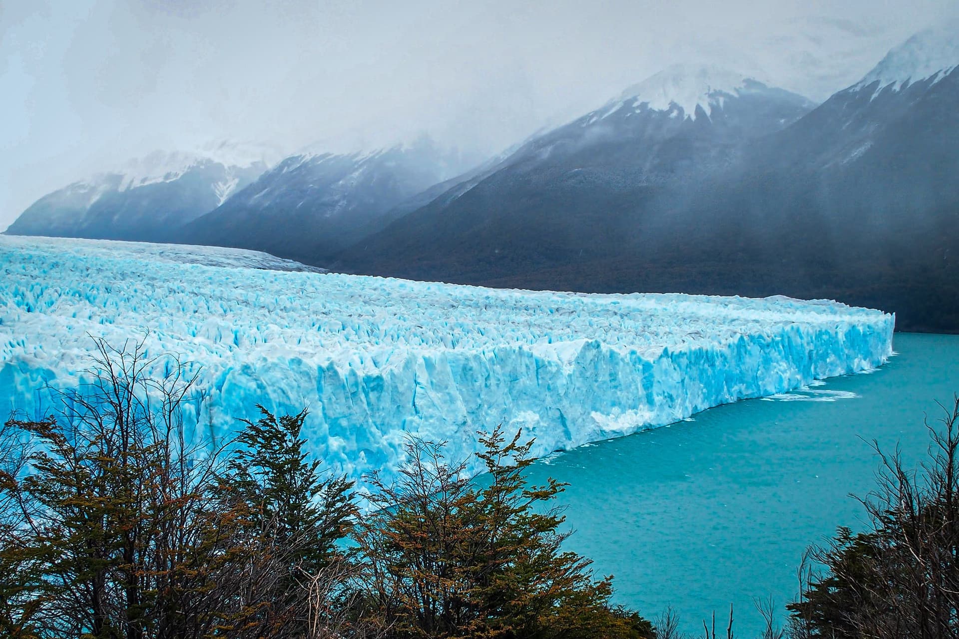
El Calafate, 220 kilometers south, is the primary base for visiting Perito Moreno Glacier, one of the world's few advancing glaciers. Many travelers spend 2 to 3 days in El Calafate for glacier tours, then drive north to El Chaltén for trekking. The two towns complement each other: El Calafate offers easier access and iconic glacier views, while El Chaltén provides immersive mountain trekking.
The village of Tres Lagos lies between El Calafate and El Chaltén, but it's primarily a stopping point rather than a destination. Some visitors break up the 3-hour drive by stopping there for lunch.
More experienced trekkers sometimes combine El Chaltén with the trek to Laguna del Desierto, a remote lake further north accessible via a longer day hike or multi-day expedition. This adds another layer to the experience but requires more planning and fitness.
Sample visit plan
A typical 3-day El Chaltén visit breaks down roughly like this. Arrive in the afternoon of day one, settle into lodging, explore the town, and plan your treks. Start the Fitz Roy trek at first light on day two, spending 9 to 10 hours on the trail. Return to town for dinner and rest. On day three, tackle the Cerro Torre trek in the morning or early afternoon, which is shorter and less demanding. This gives you two major summits' perspectives in one visit.
If you have only one full day, prioritize Fitz Roy. If you have four or more days, consider a multi-day trek into the park or a more relaxed pace with additional side hikes like Laguna Torre or Arroyo de la Laguna.
Practical tips
- Start hikes by 7 AM at the latest during peak season. Trails get crowded and you need daylight buffer for emergencies.
- There's no ATM in El Chaltén. Bring sufficient cash from El Calafate or plan to pay by card where accepted (many places don't).
- Mobile phone reception is unreliable. Don't depend on GPS or mapping apps as your only navigation tool. Pick up a printed trail map from the tourist office.
- Respect the wind. It can arrive suddenly and with force. Lightweight gear that packs small is essential.
- Many restaurants close between lunch and dinner service, typically 3 PM to 6 PM. Plan meal timing accordingly.
- Bring sunscreen and lip balm. The sun reflects intensely off light-colored rock and can burn you quickly at this latitude.
- If hiring a guide, book through your hostel or the tourist office. Guides are experienced with local conditions and can adjust pace and route based on your fitness and weather.
- Don't attempt full-day hikes if you're significantly altitude-unaccustomed. Spend at least one day acclimatizing, especially if you arrived from sea level recently.
FAQ
Do I need mountaineering experience to trek here? No. The main trekking routes (Fitz Roy and Cerro Torre approaches) don't require climbing skills or special equipment. They're steep and demanding, but accessible to anyone with reasonable fitness and proper footwear. Actual mountaineering (summiting the peaks) requires technical training and experience.
How fit do I need to be? The Fitz Roy trek involves 9 to 10 hours of hiking with significant elevation gain. You should be comfortable walking for extended periods and climbing steep sections. If you can handle a moderately strenuous 4 to 5 hour hike, you can manage the approach to the viewpoint, though you might move slowly.
What if the weather is bad? Bad weather happens frequently. If visibility is poor or conditions are dangerous, don't go. The mountains aren't going anywhere. Wait for a clear day. Most people spend a few days in El Chaltén waiting for conditions, and it's worth it for safety and photos.
Can I trek solo? Yes, the trails are well-marked and popular. Thousands of solo hikers trek here safely each year. That said, hiring a guide adds confidence and local knowledge. Consider it if you're inexperienced with high-altitude hiking or uncomfortable hiking alone.
Is the town expensive? Prices are higher than in larger Argentine cities due to remote location and tourism demand. Lodging and food are mid-range. Budget for accommodation and meals similar to a European mountain town, not a typical Argentine village.
Reviews
Sign in and mark this place visited to leave a review.
No reviews yet.
Free Trip Planner
Plan your El Chaltén trip with our free planner
Build a day-by-day itinerary with AI suggestions, hand-picked places, and friends. Free forever — no credit card.