New York Skyline
Overview
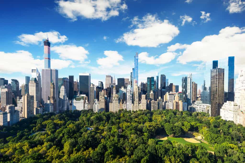
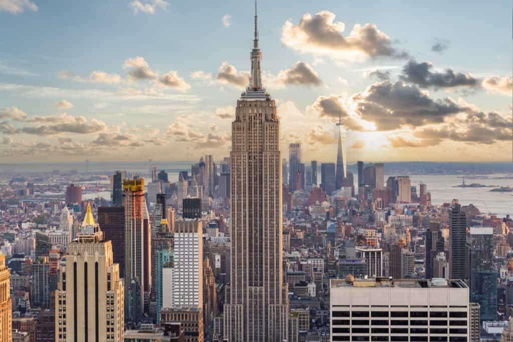
The New York Skyline is the collective silhouette of Manhattan's buildings, bridges, and landmarks as seen from vantage points across the city and its surrounding areas. Unlike a single museum or monument, the skyline itself is the attraction. It shifts depending on where you stand, the time of day, and the season. From certain angles, you see the Empire State Building and Chrysler Building dominating the view. From others, One World Trade Center and the newer residential towers take center stage. The skyline tells the story of New York's constant reinvention, with structures from the 1930s standing beside glass-and-steel additions from the 2000s and 2010s.
Most visitors experience the New York Skyline from multiple viewpoints rather than one fixed location. Each vantage point offers a different perspective on the city's scale and architecture. The skyline at sunset looks nothing like the skyline at night. Rain, fog, and clear weather all transform what you see.
Why this place matters
The New York Skyline has become a symbol of the city itself, recognized worldwide. It represents American ambition, architectural innovation, and urban density. The skyline changed dramatically on September 11, 2001, when the Twin Towers fell. Today, One World Trade Center stands 1,776 feet tall at the same site, marking both loss and renewal.
Architecturally, the skyline showcases different eras. The Art Deco towers of the 1930s set the tone for the city's vertical ambition. Mid-century modernism added clean lines and steel frames. Contemporary glass and mixed-use towers now dominate new construction. Walking or traveling through New York, you're constantly moving through this visual history.
Quick facts
- Empire State Building completed in 1931, 102 stories, 1,454 feet tall
- One World Trade Center opened in 2014, 1,776 feet tall including antenna
- Chrysler Building finished in 1930, recognizable by its stainless steel crown
- Best viewing times typically early morning, sunset, and after dark
- Free to view from most public spaces and bridges around the city
- Manhattan covers 23 square miles and contains over 6,000 high-rise buildings
Getting there
You don't travel to the skyline as you would to a museum. Instead, you position yourself to see it. The most famous viewpoint for tourists is the Brooklyn Bridge, which takes about 20 to 30 minutes to walk across from the Brooklyn side. The bridge puts you close to Lower Manhattan's tallest towers.
From Manhattan itself, head to Riverside Park on the Upper West Side around West 80th Street for an unobstructed western view. The East River Waterfront near South Street Seaport offers views of the Financial District. If you take the subway to the top of Manhattan, the George Washington Bridge area gives you a completely different perspective on the skyline from the north.
The Staten Island Ferry, which costs a few dollars each way, travels directly toward Lower Manhattan. The 25-minute ride passes Battery Park and the Statue of Liberty with the skyline as your backdrop.
The layout and experience
Manhattan's skyline is divided into distinct zones, each with its own visual character. Downtown, anchored by One World Trade Center and the Financial District's cluster of towers, presents a dense, modern face. Midtown, where the Empire State Building and Chrysler Building stand, showcases the city's Art Deco heritage alongside contemporary glass towers. Uptown transitions to lower-density residential neighborhoods, though the skyline remains visible from many spots.
What makes the New York Skyline compelling is how it changes as you move. A view from Williamsburg, Brooklyn looks directly at the Empire State Building and the canyon of Midtown towers. The same view from the Lower East Side is more intimate and fragmented. From Jersey City or Hoboken, the skyline presents itself as a unified wall of light and structure.
The skyline is most dramatic when you're at water level or elevated. Ground-level views from street level in Manhattan show you individual buildings but lose the collective impact. The best experiences come from viewpoints that give you height without obstruction, or from water-based positions that let you see the full profile.
Main highlights
The Empire State Building remains the most iconic silhouette. Completed in 1931, it held the title of world's tallest building for 40 years. Its stepped Art Deco crown is instantly recognizable, especially when lit at night. The building itself is open to visitors with ticketed observation decks, but its role in the skyline view is equally important.
The Chrysler Building's stainless steel crown glimmers in daylight and glows at night. Built in 1930, it was briefly the world's tallest building before the Empire State Building surpassed it. From certain angles, especially from the Brooklyn Bridge or the East River, the Chrysler Building's crown stands out as a jewel among the other towers.
One World Trade Center defines the downtown skyline today. Its spire reaches 1,776 feet, a height chosen to reference the year of American independence. The building's glass facade catches and reflects light differently throughout the day. At night, it's illuminated in changing colors.
The Brooklyn Bridge itself is part of the experience. Walking it at dawn or dusk, with the skyline ahead of you, puts you in the middle of the view rather than distant from it. The bridge's Gothic stone towers frame the Manhattan skyline perfectly.
History and background
New York's vertical growth began in earnest in the late 1800s as iron and steel frame construction made tall buildings possible. The Flatiron Building, completed in 1902, was one of the first true skyscrapers. By the 1920s and 1930s, the skyline became a competition for height and architectural distinction.
The Great Depression and World War II slowed construction, but the post-war period brought an explosion of office towers. The 1960s through 1980s added glass-clad modernist buildings that changed the skyline's aesthetic. The Twin Towers of the World Trade Center, completed in 1973, dominated the downtown skyline for 28 years until September 11, 2001.
The early 2000s saw the skyline slowly recover and transform. Battery Park City developed as a planned neighborhood with residential towers. Hudson Yards brought a new cluster of supertall buildings to the far west side of Midtown. The skyline continues to evolve as older buildings are renovated and new ones rise.
Best time to visit
Clear days offer the most dramatic views, but New York's skyline is compelling in most weather. Winter tends to have clearer air, though colder temperatures keep many indoors. Summer brings haze and humidity but also longer daylight hours. Spring and fall offer moderate temperatures and often crisp, clear light.
Time of day matters as much as weather. Sunrise creates a soft light that emphasizes the skyline's silhouette. The golden hour before sunset bathes the buildings in warm tones. Night brings the full effect of the city's lighting, with thousands of windows illuminated and architectural lighting highlighting key towers. Blue hour, the 20 to 30 minutes after sunset before full darkness, offers a balance of natural and artificial light.
Weekdays and off-peak hours mean fewer crowds at popular viewing spots like the Brooklyn Bridge. Early morning, especially on weekdays, gives you breathing room to stand and take in the view.
Photography tips
The skyline photographs best from water level or elevated positions. The Brooklyn Bridge is a popular spot, but crowds can make framing difficult. Try photographing from the less-crowded Manhattan Bridge or Williamsburg Bridge for similar angles with more space.
Shooting from the Staten Island Ferry gives you a moving vantage point with unobstructed views. The ride out and back means you see the skyline from multiple angles. Early morning or late evening sailings have softer light and fewer passengers.
For night photography, the East River waterfront near South Street Seaport or the Battery Park promenade offers stable positions. A tripod helps capture the city lights without excessive noise. The reflection of lights in the water adds depth to the image.
Wide-angle lenses capture the full scale of the skyline. Telephoto lenses let you compress the view and emphasize the density of towers. The best approach is to shoot with multiple focal lengths from the same spot to see how perspective changes.
Facilities and preparation
Most skyline viewing spots are free and open to the public. Popular areas like the Brooklyn Bridge have no admission. Some paid observation decks offer elevated, weather-protected views if you want to spend more time looking.
Wear comfortable walking shoes if you plan to move between viewing spots. The Brooklyn Bridge is about 1.3 miles long. Riverside Park and waterfront paths involve significant walking. Bring water and dress for the weather, as many viewpoints offer no shelter.
If you're shooting photography, bring a tripod if you want to shoot at dusk or night. A smartphone is sufficient for daytime photography, though a camera with manual controls gives you more flexibility with light and composition.
Check tide tables if you're viewing from water-level spots during different times of year. The Hudson River and East River waterfront can look different depending on water levels and seasonal changes.
How it compares to similar places
Other major cities have impressive skylines, but New York's combines density, age, and architectural diversity in ways few others match. Chicago's skyline is more uniform in style and height. Hong Kong's skyline is denser but lacks the historical depth. London's skyline is intentionally limited by planning restrictions. San Francisco's skyline is broken up by geography and water.
What distinguishes the New York Skyline is that it's experienced from within the city, not from a distance. You're constantly among the buildings that make the skyline, not viewing them from a separate observation point. This creates a different relationship to the view.
Combining with nearby attractions
A skyline viewing experience works well combined with other Lower Manhattan attractions. After walking the Brooklyn Bridge, explore DUMBO or Williamsburg on the Brooklyn side. The South Street Seaport is a short walk from skyline viewing spots in Lower Manhattan. Battery Park offers views of the Statue of Liberty and Ellis Island in addition to the skyline.
From Midtown, you can visit the Empire State Building observation deck or walk through Rockefeller Center, both of which put you among the buildings that make up the skyline. The High Line, an elevated park on the west side of Midtown, offers skyline views while you walk through a green space.
Sample visit plan
Start your morning on the Brooklyn Bridge at sunrise or shortly after. Walk it slowly, stop at midpoint, and photograph the view. The bridge takes 20 to 30 minutes to cross comfortably.
After crossing into Manhattan, explore the South Street Seaport area. Walk the waterfront path south toward Battery Park. This takes an hour or more depending on your pace and stops.
In the afternoon, take the Staten Island Ferry from Whitehall Terminal. The ride takes 25 minutes each way and gives you a completely different perspective on the skyline from the water.
As evening approaches, position yourself for sunset. The Riverside Park area on the Upper West Side, or the waterfront near South Street Seaport, both work well. Stay until after dark to see the night skyline fully illuminated.
Practical tips
- Bring layers. Waterfront areas are cooler than inland spots, especially at dawn and dusk.
- The best skyline photos often come from bridges and water-level spots rather than from tall buildings.
- Visit on a day with good visibility. Check weather forecasts for cloud cover and visibility, not just rain.
- The skyline looks completely different from each borough. Spend time in Brooklyn, Queens, and Jersey City for varied perspectives.
- Avoid midday light if you're photographing. The harsh overhead sun flattens the skyline and creates heavy shadows.
- Download an offline map of the city. Skyline viewing spots are spread across multiple neighborhoods.
FAQ
Is there a best viewpoint for seeing the entire skyline? No single spot shows the entire skyline as a unified view. The Brooklyn Bridge shows Lower and Midtown Manhattan clearly. Riverside Park shows Midtown and Upper Manhattan. For the complete view, you need to visit multiple locations.
Can you see the skyline from the top of the Empire State Building? Yes, but it shows you the city surrounding the building rather than the skyline itself. You're looking out from within the skyline rather than looking at it. The observation deck is worth visiting for its own experience, but it's different from viewing the skyline from a distance.
How much does it cost to view the New York Skyline? Most viewpoints are free. The Brooklyn Bridge, waterfront parks, and many streets offer no-cost views. Paid observation decks at tall buildings charge admission, but they're optional if your goal is simply to see the skyline.
What's the best season for skyline photography? Winter offers clearer air and sharper detail. Fall has good light and comfortable temperatures. Summer has longer daylight but more atmospheric haze. Spring is variable. Choose based on your tolerance for cold and crowd preferences rather than season alone.
Reviews
Sign in and mark this place visited to leave a review.
No reviews yet.
Free Trip Planner
Plan your New York trip with our free planner
Build a day-by-day itinerary with AI suggestions, hand-picked places, and friends. Free forever — no credit card.
Things to see near New York Skyline



Places to eat or drink near New York Skyline

Nathan’s Famous Hotdogs

Totonno's

Randazzo’s Clam Bar