Tulum Archaeological Site
Carretera Federal, Cancun - Chetumal Km 230, 307, Tulum 77780 MexicoTulum Archaeological Site: Cliffside Maya Ruins Above the Caribbean
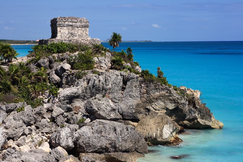
The Tulum Archaeological Site sits on a limestone bluff roughly 12 meters above the turquoise water of the Caribbean Sea, making it one of the most photographed Maya ruins in Mexico. Unlike the massive inland complexes at Chichen Itza or Uxmal, Tulum is compact, coastal, and genuinely dramatic. The views alone would justify a visit. The ruins themselves add a layer of context that most beach towns in the Riviera Maya simply can't offer.
It draws a lot of visitors. That's worth knowing upfront. But if you approach it with a plan, the experience holds up.
Why Tulum Archaeological Site Matters
Tulum was one of the last cities built and inhabited by the Maya, flourishing as a major trading port roughly between the 13th and 15th centuries. When Spanish sailors spotted it from the sea in 1518, it was still a functioning city, which makes it unusual among Maya sites where occupation had long since ended. Its position on the coast wasn't incidental. The Maya used Tulum as a hub for trading jade, turquoise, and obsidian along Caribbean sea routes.
The site is also enclosed on three sides by a stone wall, one of the few walled Maya cities ever discovered. That wall, combined with the sea cliff on the fourth side, gave the city a defensible position that most inland ceremonial centers lacked. Tulum was built for real life, not just ritual.
Quick Facts
Location: Carretera Federal Cancun-Chetumal Km 230, about 2 kilometers from the town of Tulum
Managed by: INAH (Instituto Nacional de Antropología e Historia)
Size: Roughly 6 hectares of walkable ruins within the walled city
Main structures: El Castillo, the Temple of the Frescoes, the Temple of the Descending God
Entry type: General admission, purchased at the site entrance or through INAH's online system
There is an additional fee collected by the municipal government at the access road
Open daily, including most public holidays
Photography: Permitted throughout the site without additional charge
Getting There
From the town of Tulum, the site entrance is roughly a 10-minute drive north along Federal Highway 307. If you're coming from Cancun, count on about two hours by car depending on traffic, or a similar time by ADO bus to Tulum town followed by a taxi or colectivo to the ruins. From Playa del Carmen, the drive runs closer to 90 minutes.
Parking is available at the site, and shuttle carts run the few hundred meters from the parking area and ticket booths to the actual ruins entrance. The walk is manageable, but the carts are worth using in midday heat.
Colectivos (shared vans) running Highway 307 between Playa del Carmen and Tulum drop passengers near the access road. From there, taxis or mototaxis cover the last stretch to the entrance. It's a genuinely workable option if you're traveling without a car.
The Layout and Experience
Once you pass through the ancient stone wall, the site opens into a flat, well-maintained area of ruins set against open sky. The path is mostly unpaved but easy to walk. There's no single prescribed route, and most visitors naturally drift toward El Castillo first since it's visible from nearly every angle.
El Castillo is the dominant structure, a stepped pyramid sitting right at the cliff's edge. It served as a lighthouse of sorts, with openings in its upper chamber believed to have guided canoes through gaps in the reef below. The views from the area around El Castillo, looking east over the sea, are the ones you've seen on every travel magazine cover featuring Tulum.
The Temple of the Frescoes is smaller but arguably more interesting up close. The exterior carvings and interior painted murals, though now protected behind a rope barrier, show Maya deities and cosmological imagery that survived centuries in reasonable condition thanks in part to the building's sheltered design. The detail rewards a slow look.
The Temple of the Descending God, named for the unusual upside-down figure carved above its doorway, appears in several structures throughout the site. Scholars still debate exactly what or who the figure represents, which makes it one of those details that lingers after you leave.
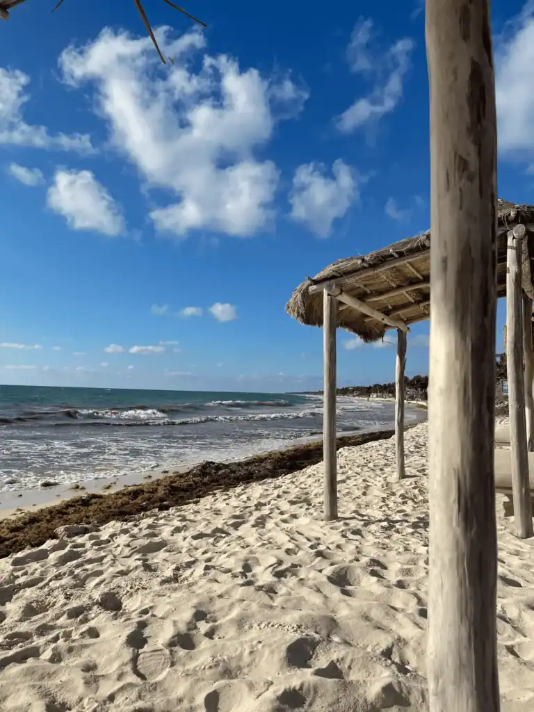
Down below the cliff, there is a small beach accessible by a steep staircase. On calmer days, swimming is possible there. It's one of the more surreal swimming spots on the Yucatan Peninsula, sitting directly beneath a 13th-century trading port.
History and Background
The name Tulum means "wall" or "fence" in Yucatec Maya, a reference to the stone enclosure that still stands in large sections. The city's original Maya name was Zama, meaning "dawn" or "city of the dawn," which fits given its east-facing position and the way morning light hits the Castillo.
The site reached its peak influence during the Postclassic period, roughly 900 to 1521 CE, and maintained active occupation until sometime in the early colonial period. By the late 16th century, epidemic disease and Spanish colonial disruption had emptied most coastal Maya settlements, including Tulum. The ruins were formally documented by Western explorers in the 19th century, and serious archaeological work began in the early 20th century under INAH.
Tickets and Entry
Entry requires two separate payments. The first is a fee collected at the access road by the municipality of Tulum. The second is the federal INAH admission at the site itself. Both are general admission and straightforward to pay, but having cash on hand for the municipal fee tends to speed things up.
Guided tours are available from operators in Tulum town and through most hotels in the Riviera Maya. A knowledgeable guide makes a real difference here. The ruins are well-preserved but minimally labeled, and the iconography inside structures like the Temple of the Frescoes is easy to walk past without context.
Best Time to Visit
Arrive as early as possible. The site opens in the morning and the first hour or two draws far smaller crowds than midday, when tour buses from Cancun and cruise ships from Cozumel arrive in volume. By late morning on a busy day, certain areas around El Castillo can feel genuinely congested.
The dry season, roughly November through April, brings the most comfortable temperatures and reliable weather. Visiting between May and October means higher humidity and occasional afternoon rain, but also thinner crowds mid-week. The heat between 11am and 3pm in any season is intense. Shade at the site is limited, so a hat and water are non-negotiable.
Photography Tips
The best light on El Castillo is in the early morning, when the sun rises behind the structure and casts long shadows across the ruins. If you want that classic shot of the Castillo with blue water behind it, position yourself to the south of the structure and shoot slightly north-northwest.
You cannot climb the main structures, and barriers keep visitors away from the most sensitive facades. A zoom lens helps with the carvings on the Temple of the Frescoes, where the rope line keeps you several meters back. The small beach below the cliff, if you make it down there, offers a completely different perspective looking back up at the ruins from sea level.
Combining with Nearby Attractions
The archaeological site sits just north of Tulum town and the hotel zone, which means combining it with a beach afternoon is easy and logical. Playa Paraiso, one of the more accessible stretches of sand near the ruins, is only a few minutes by car.
The Gran Cenote, one of the most visited freshwater sinkholes in the region, is about 4 kilometers west of Tulum town and makes a natural pairing for a morning ruins visit followed by a midday swim. The Sian Ka'an Biosphere Reserve, a UNESCO-listed protected area, begins just south of the Tulum hotel zone and offers boat tours, birding, and near-empty beaches for those willing to arrange transport.
Practical Tips
Bring cash for both the municipal fee and the INAH admission, even if you plan to pay the INAH fee online
Wear sunscreen and a hat. There is almost no shade once you're inside the walled site
Closed-toe shoes or sturdy sandals work better than flip-flops on the uneven ground
Water is sold near the entrance but bring your own to avoid the markup and reduce plastic
If you're visiting from Cancun or Playa del Carmen, leaving by 7am puts you at the site before the crowds peak
The shuttle cart from the parking lot to the ruins entrance is included in the price and worth using
Iguanas are abundant throughout the site. They're harmless and photogenic, but don't feed them
FAQ
Can you swim at the beach inside Tulum Archaeological Site?
Yes, there's a small beach at the base of the cliff accessible via a staircase inside the site. Swimming is possible on calm days, though the beach is narrow and the waves can be strong depending on conditions. It's worth the detour even if you just want to see the view back up at the ruins from the water's edge.
How long does a visit typically take?
Most visitors spend between one and two hours inside the walled area. If you want to take your time with the structures, visit the beach below, and explore the outer wall sections, plan for closer to two and a half hours. Guided tours tend to run about 90 minutes.
Is Tulum Archaeological Site accessible for visitors with mobility limitations?
The main paths within the site are relatively flat and walkable, and the shuttle carts from the parking area help reduce the overall walking distance. However, some areas involve uneven terrain, and the staircase down to the beach is steep and not accessible to everyone. It's worth checking with INAH directly for current accessibility information before your visit.
Do I need to book tickets in advance?
Advance booking through INAH's online system is possible and can save time at the gate, particularly during the high season between December and March. Walk-up tickets are generally available, but lines can be long during peak hours. Arriving early reduces the need to book ahead.
Reviews
Sign in and mark this place visited to leave a review.
No reviews yet.
Free Trip Planner
Plan your Mexico trip with our free planner
Build a day-by-day itinerary with AI suggestions, hand-picked places, and friends. Free forever — no credit card.
Related reading

Things to see near Tulum Archaeological Site
Amansala Resort Beachclub and Spa

Avenida Kukulkan
Tulum Tower

