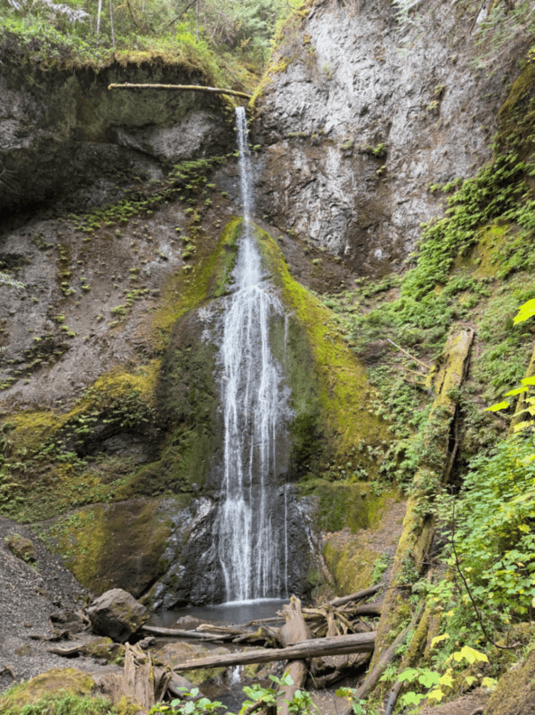
Marymere Falls
Marymere Falls, Washington 98363, USAMarymere Falls sits inside Olympic National Park, a short drive west of Port Angeles on the forested north shore of Lake Crescent. The waterfall itself drops about 90 feet over a mossy rock face in a grove of old-growth Douglas fir and hemlock, but the real draw for most visitors is the walk to get there. The trail to Marymere Falls is one of the most approachable hikes in the park, which is why it shows up on so many short lists for families, first-time visitors, and anyone looking for a quick dose of Olympic rainforest without committing to a full day on the trail.
It's not a dramatic, thundering cascade like some of the park's bigger attractions. It's quieter than that, tucked into a narrow ravine where the light filters down through a canopy that's been growing for centuries. That scale, both modest and old, is part of what makes it worth the stop.
Why Marymere Falls matters
Olympic National Park covers nearly a million acres, and a lot of its best scenery requires serious mileage or a backcountry permit to reach. Marymere Falls is the exception. It gives you a genuine old-growth forest experience, a creek crossing, and a waterfall payoff, all within a loop that most people finish in under an hour and a half. For visitors driving the Highway 101 loop around the Olympic Peninsula with limited time, it's often the single easiest way to get out of the car and into the forest.
The trail also passes right by Lake Crescent, one of the clearest lakes in Washington state, so you get two distinct landscapes in one short outing.
Quick facts
- Location: Olympic National Park, on the south side of Lake Crescent near the Storm King Ranger Station
- Waterfall height: approximately 90 feet
- Round-trip distance: roughly 1.8 miles
- Elevation gain: modest, generally under 200 feet
- Difficulty: easy, suitable for most fitness levels and families with older kids
- Trail surface: packed dirt path with a few footbridges, including a crossing over Barnes Creek
- Entry requirement: Olympic National Park entrance pass
Getting there
From Port Angeles, the drive west on Highway 101 along the southern edge of Lake Crescent takes about 25 to 30 minutes. Watch for signs for the Storm King Ranger Station, which also marks the main parking area and trailhead for Marymere Falls. If you're coming from the west, Lake Crescent Lodge is a useful landmark, since the trailhead sits almost directly across the highway from it.
Parking fills up during peak summer weekends, especially midday, so arriving early or later in the afternoon tends to make the whole experience less crowded. There's a vault toilet near the trailhead, and the ranger station is staffed seasonally if you want trail conditions or advice before you set out.
The trail and the hiking experience
This is the part of the visit that deserves the most attention, because the walk itself is as much the point as the waterfall at the end. The trail starts near the Storm King Ranger Station and follows a wide, well-maintained path through a mixed forest of big-leaf maple, Douglas fir, and western hemlock. Early on, you'll pass a side trail that climbs steeply toward Storm King viewpoint. Stay on the lower route if the falls are your goal, since the Storm King climb is a different, much tougher hike. The Marymere path continues along fairly flat terrain for the first stretch, crossing Barnes Creek on a footbridge. From there the trail splits into a small loop that climbs gently through a grove of old-growth trees before arriving at a viewing platform looking up at the falls. The elevation gain is gentle enough that you rarely feel like you're working hard, which is exactly why it's recommended as an easy hike for most people, including casual walkers and families with kids who can manage a mile or two on uneven ground. Good footwear still matters. The path can be muddy and slick in the wetter months, and tree roots cross the trail in a few spots. But there's no scrambling, no exposure, and no technical sections. Most people complete the loop in 60 to 90 minutes, including time to stop at the viewing platform.
Main highlights
The waterfall is the obvious highlight, dropping in a narrow ribbon over a rock face into a shaded pool below. The viewing platform keeps a respectful distance, so you won't get right up to the base, but the framing through the surrounding trees is part of the appeal.
Barnes Creek itself is worth slowing down for. The footbridge crossing offers a clear view of the creek running over smooth stones, and in spring the water runs higher and faster, giving the whole walk a more dramatic soundtrack.
The old-growth grove near the falls is another reason to linger. Some of the trees here have been standing long enough that their trunks are wrapped in moss and sword fern, and the canopy overhead blocks enough light that the air stays noticeably cooler than out on the highway.
Best time to visit
Spring tends to bring the most dramatic water flow, fed by snowmelt and rain, though the trail can be muddier during this period. Summer, particularly June through August, offers the most reliable weather and the easiest footing, but also the biggest crowds at the trailhead parking lot. Fall brings fewer visitors and crisp air, with the forest floor covered in fallen big-leaf maple leaves. Winter is possible too, since the trail stays open year-round, but expect wetter conditions and shorter daylight hours to shape your timing.
If you're after a quieter experience, early morning on a weekday is close to ideal. The forest holds moisture and light differently before the midday sun gets high, and you're far more likely to have the viewing platform to yourself.
Photography tips
The falls photograph best with a slower shutter speed if you want that classic silky-water look, which means a small tripod or at least a stable rock to brace against helps, since the platform area doesn't get much direct light for faster handheld shots. Overcast days actually work in your favor here, since harsh sunlight filtering through the canopy can create blown-out highlights against the shaded rock face.
Don't skip the Barnes Creek footbridge for photos. The creek's clarity and the surrounding ferns often make for a more interesting frame than the falls themselves, especially if you're shooting in the softer light of early morning.
Facilities and preparation
- Restrooms: vault toilets are available at the trailhead near the ranger station
- Water: no potable water along the trail, so bring your own
- Cell service: minimal to nonexistent once you're on the trail
- Footwear: trail runners or light hiking shoes are sufficient; waterproof boots help in wet months
- Pets: check current park rules before bringing dogs, as leash requirements and trail access can vary across Olympic National Park
- Pass: an Olympic National Park entrance pass is required to enter the park, even for a short stop
Combining with nearby attractions
Lake Crescent itself is the natural pairing. You can rent a kayak or canoe near Lake Crescent Lodge, or simply walk along the shoreline before or after your hike. The lodge also has a restaurant if you want a sit-down meal nearby, which makes it easy to build a half-day around this one stretch of the park.
If you still have energy after Marymere Falls, the Spruce Railroad Trail on the lake's north shore is a flatter, longer option along an old rail grade, with views across the water toward the mountains. For those craving more elevation and a harder workout, the Storm King side trail near the Marymere trailhead climbs steeply to a viewpoint, though it's a different undertaking altogether and not recommended for casual hikers.
Practical tips
- Arrive before 10am in summer to get a parking spot near the trailhead
- Stick to the lower loop trail if Marymere Falls, not Storm King, is your goal
- Bring layers, since the grove near the falls stays cool and shaded even on warm days
- Check current conditions at the ranger station, especially after heavy rain, since the trail can get slick
- Pack out any trash, as there are no bins along the trail itself
FAQ
Is the Marymere Falls hike suitable for kids?
Yes, the trail's gentle grade and short distance make it one of the more manageable hikes in Olympic National Park for families with children who can walk a mile or two.
How long does the hike take?
Most visitors complete the roughly 1.8-mile round trip in 60 to 90 minutes, including time at the viewing platform.
Do I need a permit to hike to Marymere Falls?
No separate permit is needed for the day hike, but you do need a valid Olympic National Park entrance pass to access the park.
Is the trail open year-round?
Yes, though conditions vary with the season. Expect muddier footing in winter and spring, and the most reliable conditions in summer and early fall.
Marymere Falls won't be the tallest or loudest waterfall you see in Washington, but for the short time and modest effort it asks of you, it delivers one of the more satisfying walks in Olympic National Park. If you're passing Lake Crescent on Highway 101, it's hard to justify skipping it.
Reviews
Sign in and mark this place visited to leave a review.
No reviews yet.
Free Trip Planner
Plan your Olympic National Park trip with our free planner
Build a day-by-day itinerary with AI suggestions, hand-picked places, and friends. Free forever — no credit card.