
DestinationsTravel Inspiration
Things to Do in Olympic National Park: Rain Forest, Peaks and Coast
By
Explore on the map
17 places from the destinations in this story. Tap a pin to open the listing.
Olympic is three parks that happen to share a boundary. There are glaciated peaks in the middle, temperate rain forest on the west side, and seventy-three miles of wild Pacific coast that is not attached to either. It is nearly a million acres, it is a UNESCO World Heritage Site and an International Biosphere Reserve, and almost none of it is reachable from the middle.
That last point is the one that ruins itineraries. There is no road across the park. Highway 101 runs around the outside in a horseshoe, so getting from the mountains to the rain forest is a two-hour drive even though they are thirty miles apart. Plan by area, not by distance, and you will have a good trip.
Everything below is on the map above.
The mountains: Hurricane Ridge
Hurricane Ridge is the only part of the high country you can drive into, seventeen miles up from Port Angeles, ending at a ridge with the interior peaks and the Bailey Range laid out in front of you and the Strait of Juan de Fuca behind. Wildflowers in July, black-tailed deer and marmots most of the summer, snow well into June.
The road is weather-dependent and closes regularly in winter, sometimes at short notice. Check the park's road conditions line before you commit to the drive, because there is nothing worse than the 101 detour after a gate closes. Obstruction Point Road, the gravel spur along the ridge, opens later than everything else and closes early.
Lake Crescent and the Elwha
Lake Crescent is the easiest great thing in the park — Highway 101 runs along its southern shore. It is over six hundred feet deep, glacially carved, and so low in nitrogen that algae barely grow in it, which is why the water is that hard blue-green and why you can see so far down. Rent a rowboat at the 1915 lodge, or walk the old railway grade on the north shore to the Devil's Punchbowl.
Marymere Falls is a ninety-foot drop about a mile from the Storm King Ranger Station on the lake's south side, through old growth and over footbridges. Easy, shaded, and a good first walk if you have just got off a ferry.
East of there, Madison Falls is a two-hundred-foot paved path to a fifty-foot fall — wheelchair accessible, and genuinely useful when not everyone in the car is hiking. It is also, for now, the end of the road: Olympic Hot Springs Road and Whiskey Bend Road are both closed to vehicles beyond it after washouts, with no repair timeline. You can walk or cycle past the barrier. You cannot drive. Anything you read about driving to Whiskey Bend or the Elwha campgrounds is out of date.
The Sol Duc valley
Sol Duc Falls is the best short waterfall walk in the park: a flat mile through old growth to a footbridge set directly over the drop, where the river splits into three channels — four when it is running high — and falls into a narrow canyon. The bridge is the viewpoint and it is permanently wet, so mind your footing.
A short drive back down the road, Sol Duc Hot Springs Resort has three mineral pools and a freshwater one. It is a developed resort rather than a wild spring, it is seasonal, and the sensible order is falls first, soak second.
The rain forests
The Hoh Rain Forest is the one everyone comes for, and it earns it. Twelve to fourteen feet of rain a year, Sitka spruce over 250 feet, bigleaf maples so loaded with club moss the branches bow. The Hall of Mosses is a flat eight-tenths-of-a-mile loop and the densest of it; the Spruce Nature Trail is slightly longer, quieter, and drops to the river. Arrive early — the car park fills by mid-morning in summer and the road in is long.
Quinault is the same forest with a fraction of the people. A thirty-one-mile loop road circles the lake, there are record-sized trees along it including one of the largest Sitka spruces in the world, and the 1926 lodge on the south shore is where Franklin Roosevelt had lunch in 1937 before signing the park into existence the next year. If the Hoh car park is full, this is not a consolation prize.
The coast
The coastal strip is a separate unit, an hour or more from the rain forest valleys, and it is the part of Olympic people remember.
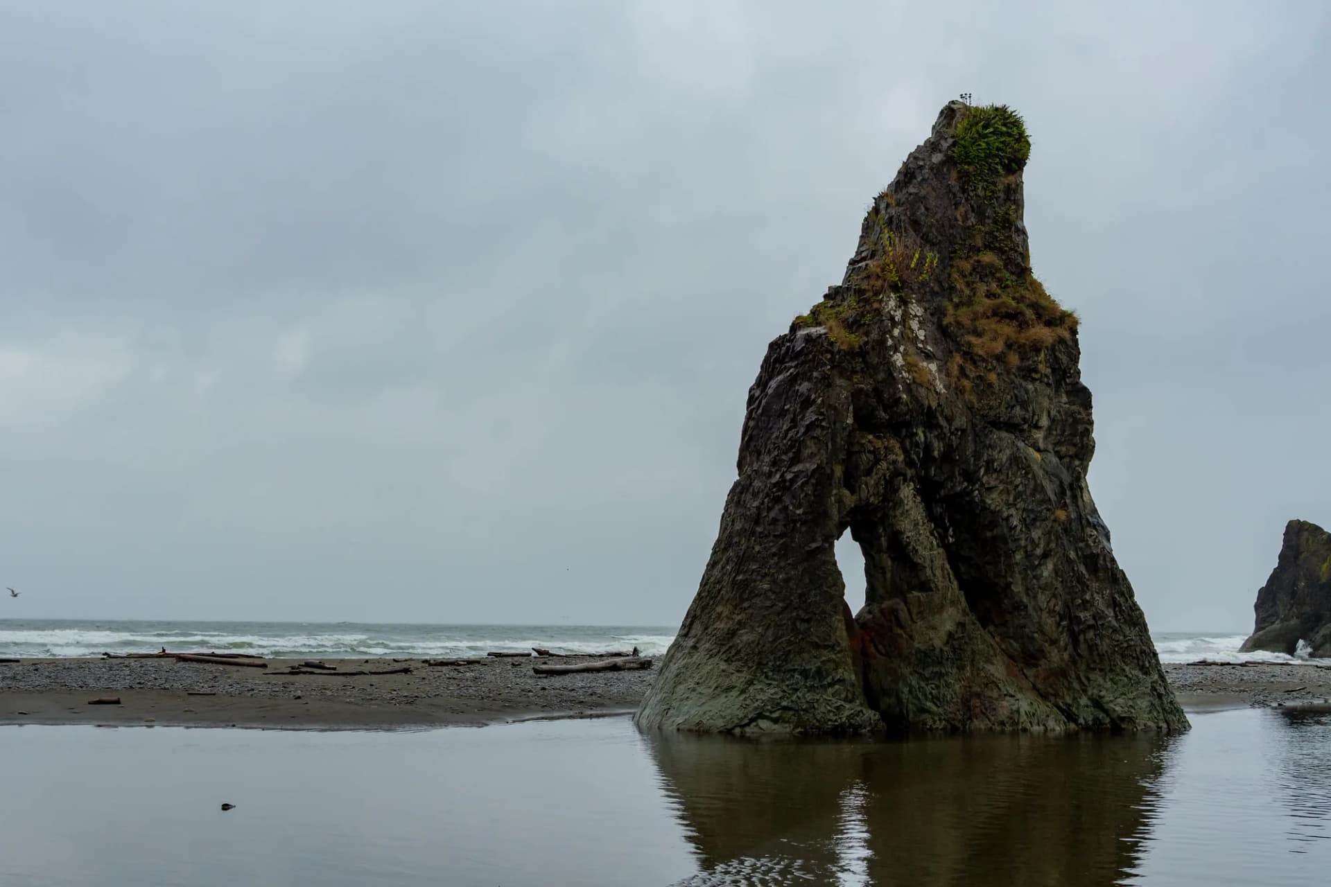
Rialto Beach is black cobble, enormous driftwood and sea stacks, with Hole-in-the-Wall a mile and a half north — a sea arch you can walk through at low tide and only look at when you cannot. Ruby Beach is the most photographed, named for the garnet in its sand, with Abbey Island just offshore and a creek running out across the beach; it is directly off the 101, which makes it the easiest sunset on the coast.
Second Beach takes a seven-tenths-of-a-mile walk through forest before the trees stop and the whole thing opens at once, which is why people rank it above the beaches you can drive to. And the Kalaloch Tree of Life is a Sitka spruce left bridging an eroded gully on a web of bare roots, still alive, two minutes from the car park.
One rule for all of them: carry a tide table. Headlands that are walkable at low water are impassable at high, and the logs in the surf line weigh tons and move.
The far corners
Cape Flattery is the northwesternmost point of the contiguous United States — three quarters of a mile of boardwalk to cliff platforms over sea caves, with Tatoosh Island and its lighthouse offshore. It is not in the national park: it is on the Makah Reservation, and you need a Makah Recreation Permit from Neah Bay, displayed in your car. Your park pass does not cover it.
Lake Ozette sits at the end of a long dead-end road and is the trailhead for the Ozette Triangle — three miles of cedar boardwalk to Cape Alava, the westernmost point in the Lower 48, three miles of beach south to Sand Point, and three miles of boardwalk back. The beach leg is tide-dependent. The boardwalk is slick when wet, which is most of the time.
In the southeast, Staircase is the quiet corner: drier forest, big Douglas fir, and a two-mile river loop over a suspension bridge above Lake Cushman. Almost nobody on a first visit goes there, which is rather the point.
Practicalities
Getting around. Highway 101 horseshoes around the park. Port Angeles is the northern base and the ferry town from Victoria; Forks is the western one and puts you closest to the Hoh and the beaches. Budget two hours between the north shore and the coast, and do not plan Hurricane Ridge and the Hoh on the same day.
Entry. One pass covers the park for a week and is sold at each entrance station. Cape Flattery and parts of the Quinault valley are on tribal land and need their own permits.
When. July to September is the dry window and the busy one. Late spring gives you waterfalls at full flow and snow still on the ridge. Winter is genuinely wet — this is the wettest place in the contiguous United States — and the rain forest in the rain is arguably better, as long as you have the gear.
Signal. There is almost none over most of the park. Download maps before you leave Port Angeles or Forks.
FAQ
How many days do you need in Olympic National Park?
Three is the realistic minimum to see all three environments: one for Hurricane Ridge and Lake Crescent, one for the Hoh, one for the coast. Two forces you to drop a section. Five lets you add Cape Flattery or the Ozette boardwalk without driving the 101 in a panic.
Can you drive through Olympic National Park?
No. There is no road across the interior. Highway 101 loops around the outside and spur roads run in from it, so every destination is an in-and-out drive. That is the single most common planning mistake people make here.
What is the best part of Olympic National Park?
The Hoh Rain Forest if you only do one thing, Rialto or Ruby Beach if you want the image that stays with you, and Hurricane Ridge if the forecast is clear. Quinault is the best substitute when the Hoh is overrun.
Do you need a permit for Olympic National Park?
An entrance pass covers the park for seven days. Wilderness camping needs a separate permit, and Cape Flattery needs a Makah Recreation Permit because it sits on the Makah Reservation rather than in the park.
When is the best time to visit Olympic National Park?
July through September for reliable weather and full access, though it is also the busiest. Late spring has the strongest waterfalls and snow still on the high country. Winter is very wet, and the rain forest is arguably at its best in it.